
Government plans to lower water levels in four high-risk glacial lakes, introduce AI-powered weather forecasting and strengthen disaster preparedness
Kathmandu, October 26: As climate change intensifies the risks of floods, glacial lake outburst floods (GLOFs) and extreme weather events, the government has unveiled a new strategy to strengthen Nepal’s hydrological and meteorological services, improve early warning systems and reduce disaster-related losses.
The Department of Hydrology and Meteorology (DHM) and the Hydrology and Water Resources Research Centre, under the Ministry of Energy, Water Resources and Irrigation, separately released two white papers, outlining plans to modernize weather forecasting, expand flood monitoring and improve climate resilience.
The documents prioritize sustainable water resource management, climate-resilient infrastructure, aviation safety and disaster risk reduction. They also emphasize the use of modern technology, open data systems and scientific research to protect lives and property.
Four High-Risk Glacial Lakes Targeted for Risk Reduction
With rising temperatures accelerating glacier melt and increasing the risk of glacial lake outburst floods in the Himalayas, the government plans to lower water levels in four high-risk glacial lakes under the proposed GLOF Sanjeevani Project.
The targeted lakes are Thulagi in Manang, Lower Arun in Sankhuwasabha, and Lumding Tsho and Hongu-2 in Solukhumbu.
The project is scheduled to run from 2026 to 2033, with a total estimated budget of US$49.9 million. It builds on previous risk-reduction efforts at Tsho Rolpa in Dolakha and Imja Lake in Solukhumbu, where water levels were successfully lowered to reduce the threat of potentially destructive outburst floods.
The initiative is expected to strengthen protection for downstream communities and infrastructure exposed to glacial lake hazards.
Flood Early Warning Systems to Expand Across Six River Basins
The government is also moving to strengthen flood forecasting and early warning coverage across six major river basins.
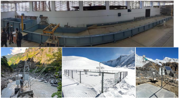
Under the Priority River Basin Flood Risk Management Project, running from 2022 to 2028, the Hydrology and Water Resources Research Centre is installing flood early warning systems in six river basins at a cost of US$7.54 million.
The centre plans to operate flood forecasting and early warning services around the clock from Jestha 1 through the end of Ashoj, covering Nepal’s main monsoon season.
In the current fiscal year, new flood forecasting models are planned for the Karnali and Narayani river basins. Meanwhile, a community-based flood early warning system will be developed under the Bagmati Improvement Project at a cost of Rs 26.1 million.
These measures aim to provide earlier alerts to vulnerable communities, giving residents more time to prepare, evacuate and protect their property before floodwaters arrive.
AI and Advanced Computing to Improve Weather Forecasts
The Department of Hydrology and Meteorology plans to introduce artificial intelligence (AI), machine learning and high-performance computing to improve the accuracy and reliability of weather forecasts.
According to the department’s white paper draft, the government will gradually upgrade 503 manual weather stations across the country to automatic weather stations, enabling more efficient and timely collection of meteorological data.
The plan also includes maintenance of weather radars in Surkhet, Palpa and Udayapur, as well as a proposal to install an X-band radar for the Kathmandu Valley.
In addition, radiosonde stations will be established in six more provinces to improve observations of upper-atmosphere conditions, which are important for weather forecasting.
The proposed technological upgrades are expected to improve the monitoring and prediction of rainfall, storms and other hazardous weather conditions.
Early Warnings to Reach Communities at Risk
Beyond improving forecasts, the government aims to ensure that warnings reach vulnerable communities in time to take protective action.
The department plans to integrate weather observation, hazard identification, impact-based forecasting, warning maps and information dissemination into a multi-hazard early warning system.
Coordination with government agencies and local governments will be strengthened to extend warnings to communities in flood-prone and other high-risk areas.
Information will be disseminated through the toll-free service 1155, mobile applications, social media and audio-visual briefings. The goal is to make weather and disaster information more accessible, understandable and actionable for the public.
Timely warnings could help communities prepare for approaching hazards, move to safer locations and reduce potential casualties and property damage.
Implementation Remains a Major Challenge
The two white papers set out an ambitious roadmap for modernizing Nepal’s hydrological and meteorological services. If implemented effectively, the proposed measures could strengthen disaster preparedness and reduce the human and economic toll of floods, glacial lake outbursts and extreme weather events.
However, translating these plans into tangible results will depend on sustained funding, the availability of skilled technical personnel, regular maintenance of modern equipment and effective coordination among government agencies.
As climate-related hazards continue to threaten mountain communities and downstream settlements, the success of the strategy will ultimately depend not only on the technologies and systems introduced, but also on how reliably they are implemented and how effectively their warnings reach people on the ground.
Full text of the white papers: